Get Instant Access to Physical Climate Risks – No Subscription Needed
Make better decisions with trusted data. Meet your climate reporting needs. Pay only for what your business needs — exclusively for registered businesses and professionals.
Location Risk Intelligence On-Demand.
Get Started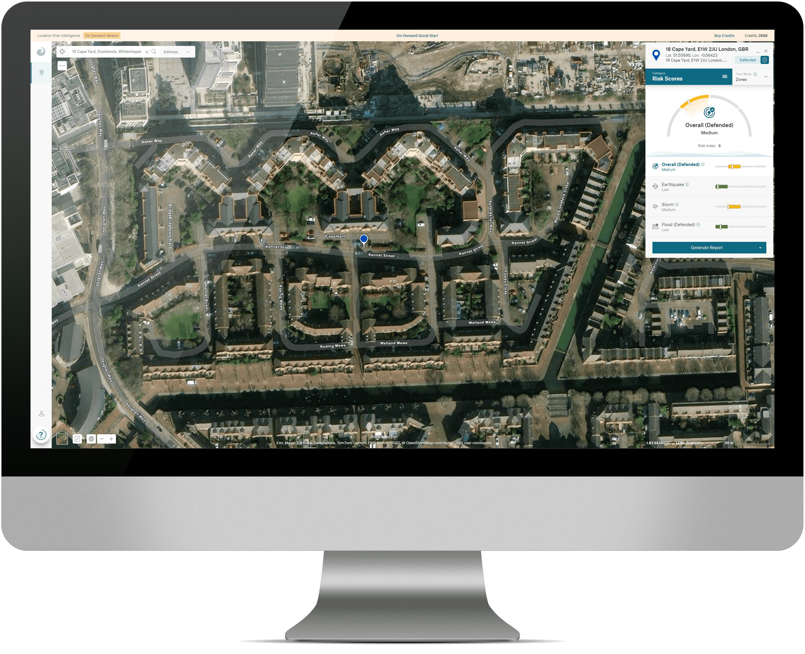


Extreme weather events increasingly threaten businesses worldwide, making it more critical than ever to understand and adapt to climate risks. Recent studies identify climate-related risks as the biggest business risk today. To safeguard your organization’s future, it’s essential to assess and manage these risks effectively. With growing transparency and regulatory reporting requirements, the demand for reliable physical climate risk data has surged.
Munich Re’s Location Risk Intelligence On-Demand offers a risk assessment solution that’s easily accessible and affordable for organizations of any sizes. Whether you’re making investment decisions, managing risks, or preparing climate reports, our On-Demand service equips you with trustworthy, up-to-date insights for single locations (not entire portfolios), empowering you to make informed business decisions that drive success. This subscription-free solution not only helps you understand your exposure to current physical risks, but also enables you to analyse and assess projected changes in the intensity and frequency of future events for single locations.
Your climate risk analyses are available in two distinct variants that meet different requirements.
Get started now:

Create an Account
Location Risk Intelligence On-Demand is exclusively available for registered businesses and professionals. Sign up, purchase credits, and start your business access right away.
Choose the package that fits your needs: Maximize your savings by opting for larger packages. Both the Climate Change Edition and Reporting Edition reports are available at the same price. Use your credits flexibly across both report types.

Enter any address or coordinate
Input your desired address or coordinates in the search field, and our tool will zoom in to the exact location, showing both the address and coordinates. Click "Calculate Scores," confirm the charge (48 credits per location), and the risk assessment will begin instantly.

Get your results
In seconds, a detailed risk assessment displays in a clear panel. Download your results as PDF, Excel, or CSV files in your preferred format, and easily proceed to another query. Remember to save the location for future access.
**All prices are quoted net of Value Added Tax (VAT). Applicable VAT will be calculated at checkout.
 Climate Change Edition
  Pay only for what you need
 The right data for every requirement
 All the data you need to succeed
 Precisely tailored to your demands
 Easy input – fast output
 Munich Re has you covered
entire portfolios or infrastructure?